GIS and SharePoint form tag team for Santos
At the 5th Annual Australian SharePoint Conference, oil and gas producer Santos will outline a solution it has implemented to automate the tagging of documents held in SharePoint through integration with an Oracle Spatial Geographic Information System (GIS).
Santos required SharePoint-based content to be associated (tagged) with GIS data objects. Meanwhile users of the GIS need to be able to quickly assemble a query that can return relevant content stored in SharePoint within the context of a GIS entity.
Previous efforts to provide a GIS tagging capability for SharePoint suffered from a number of drawbacks including a lack of Filter and Grouping Support. Also, the use of custom Field Types in SharePoint would complicate any future upgrades by Santos from SharePoint 2010. In order to address these issues, Teraterra and Kaboodle software teamed up to develop a more scalable, robust and flexible solution. Teraterra and Kaboodle Software are both independent software companies working in the Adelaide metropolitan area which specialise in Oracle Spatial (GIS) and SharePoint technologies respectively.
Santos required a solution that would improve information discovery for both GIS and SharePoint users and enable GIS data to be used for data filtering, grouping and search refinement.
It needed to extend the UI of both the GIS and SharePoint, surface SharePoint search capability in the GIS and facilitate the tagging of SharePoint documents with GIS data attributes. Santos also required that it be easily upgradable to future versions of SharePoint and the GIS.
Kaboodle CEO Colin Gardner said, “Santos had implemented an earlier solution which placed too much of a tagging burden on SharePoint users. Documents had to be tagged with up to a dozen GIS properties using custom field types with a one-to-one mapping that had to be manually selected by the user.
“The new solution we have developed uses the Managed Metadata Service (MMS) in SharePoint 2010. But instead of having the MMS/taxonomy tags created manually by somebody, we came up with a way for the creation of those to be actually be done by the GIS.
“So what actually happens is that when a user tags a document with a GIS object, behind the scenes an event handler files those synchronously without the user even being aware. That GIS web service then says “You’ve tagged this document with this GIS object, let me go away and find out what I know about this object”.
“So it calls the GIS web service with its ID, and then the Web service returns a whole bunch of properties about this, whatever the user’s tagged it with.
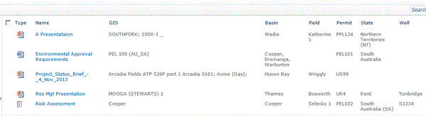
“So if a user tags a document with a Well Name called “Moomba 1” for instance, the GIS web service says “Yeah, I know what State this is in, the Tenement, Field and Basin related to the well location in the GIS and it becomes a self-tagging system. So once the GIS data is in SharePoint, then you can exploit it with search and filtering and indexing.”

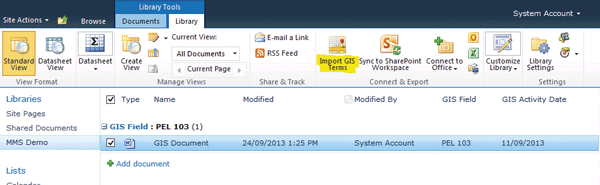
The Import Term Button shows in two locations, namely the Document Item Property Edit Page and the Connect & Export group of the Library Ribbon as shown above.
This screenshot shows both the primary GIS field and the secondary fields Basin, Field, Permit, State and Well which have been populated with values returned from the GIS Web Service